
Viewpoint
Pointe Saint-Gildas
Préfailles · Loire-Atlantique
A rocky headland listed as a regional nature reserve, with views over the bay of Bourgneuf, the Loire estuary, Noirmoutier and the offshore wind farm.
- Suggested time
- 1 h to 2 h 30, depending on the route and a possible visit to the semaphore.
- Type of place
- Viewpoint
- Atmosphere
- Very maritime, nature-focused and easy to explore.
- Getting there
- Easy road access to Préfailles, then walking paths around the headland.
Who this place suits
- With family
- 9/10
- As a couple
- 9/10
- With friends
- 9/10
- Solo
- 8/10
- With a dog
- 7/10
- Reduced mobility
- 7/10
These scores are calculated from what the page records: official rating, facilities, difficulty, duration and location. They are a guide, not a substitute for contacting the venue, especially about accessibility.
About
The Pointe Saint-Gildas is one of the best sites on the Côte de Jade for combining nature, heritage and views. A regional nature reserve since 2014, it covers more than 11 hectares. Loire Atlantique Tourisme lists 341 plant species, 85 of them remarkable, and 421 animal species. The coastal path offers views over the bay of Bourgneuf, the Loire estuary, Noirmoutier and the Saint-Nazaire offshore wind farm. The local 7 km circuit makes it easy to extend the visit.
What you will see
- Type of site: a rocky headland and regional nature reserve.
- Main view: the bay of Bourgneuf, the Loire estuary, Noirmoutier and the Saint-Nazaire offshore wind farm.
- Walking: very short for the first viewpoints, up to several kilometres for the full circuit.
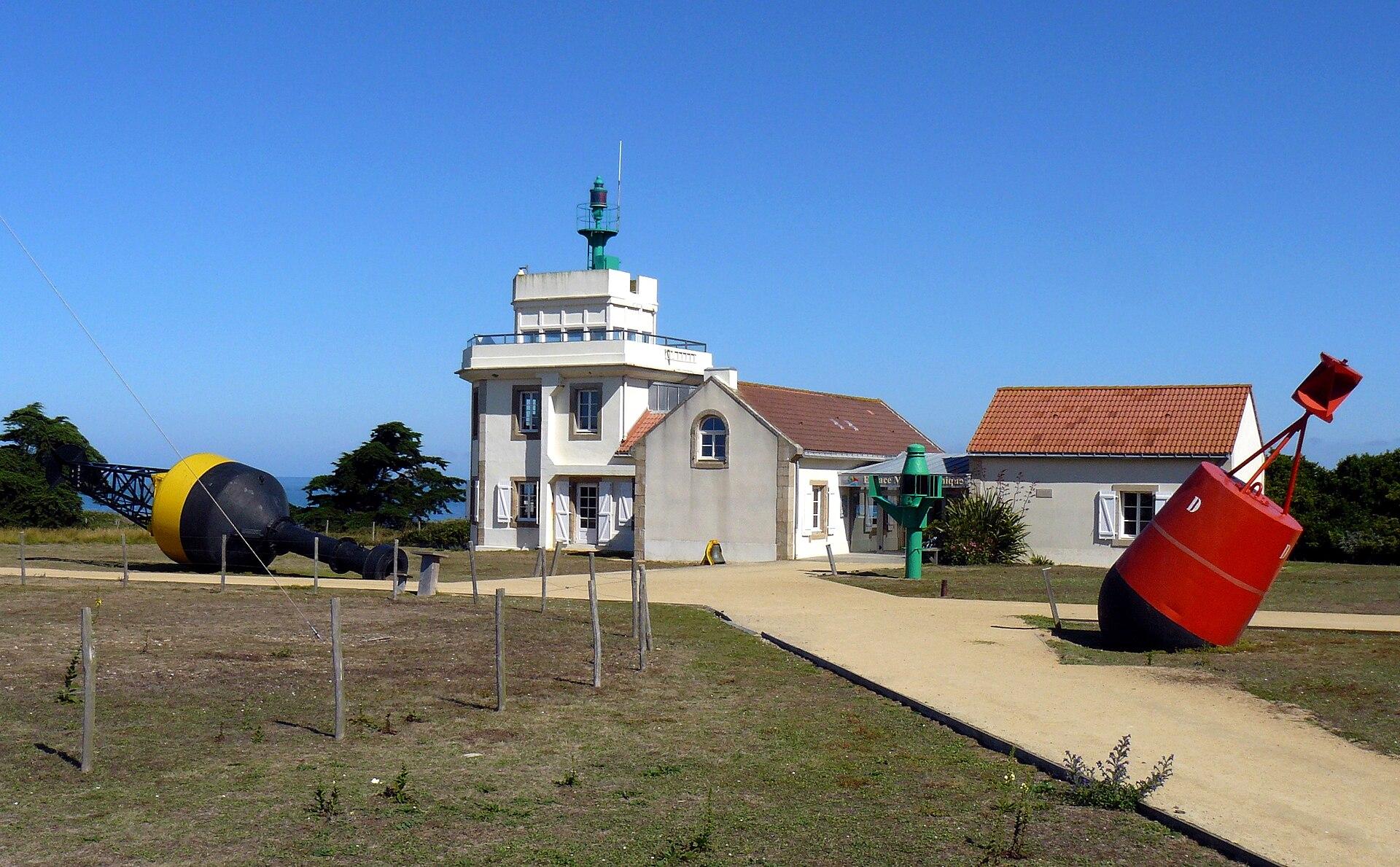
- Heritage: a former lookout post that became a semaphore in 1865, then a lighthouse in 1954.
- Environment: a regional nature reserve since 2014, covering more than 11 hectares.
- 341 plant species are recorded, according to Loire Atlantique Tourisme, 85 of them remarkable.
Show 2 more pointsHide
- 421 animal species are recorded.
- The view can reach as far as Noirmoutier.
Practical information
- Address
- Pointe Saint-Gildas, 44770 Préfailles
- Getting there
- Easy road access to Préfailles, then walking paths around the headland
- Public transport
- A car is practical; local access may be possible on the seasonal network
- Services
- Services and facilities in Préfailles; semaphore and car parks in the area
- Parking
- Parking near the headland
- Pets
- Yes, on a lead and respecting the reserve
- Accessibility
- Some paths are accessible, but the reserve also has natural trails
- Pushchair
- Partly possible, depending on the stretch
- Difficulty
- Easy
- Safety
- Usual care near the cliffs and coves
- Best time
- Late afternoon, or high tide for a more maritime atmosphere; all year
- Photography
- Excellent for views, cliffs, the Roche Percée and the semaphore
- Nearby
- Préfailles, the Roche Percée, the semaphore, La Plaine-sur-Mer, Pornic
Tips on the spot
- Check the local weather on the day; in fog or very poor visibility, postpone if the view is your main aim.
- Come in the morning or late in the day for softer light and fewer people.
- Bring a windproof and waterproof layer: the wind makes it feel much colder.
- Wear shoes with good grip; after heavy rain, paths can be muddy or slippery.
- Never cross a fence or safety marking for a better photo, and stay back from the cliff edge in strong wind.
Show 8 more tipsHide
- With children, be especially careful near cliffs, rocks and exposed areas; keep dogs on a lead.
- Stay on the paths to limit erosion, and take all your litter home.
- Do not count on toilets at the viewpoint, and bring water if the site is isolated.
- Do not fly a drone without checking the rules, and do not disturb seabirds.
- For sunset, plan your walk back after dark and bring a small torch.
- Walk the 7 km circuit if you have two hours.
- Strictly follow the nature reserve’s rules.
- Keep your dog on a lead.
Frequently asked questions
What kind of viewpoint is it?
A rocky headland and regional nature reserve.
What can you see from it?
The bay of Bourgneuf, the Loire estuary, Noirmoutier and the Saint-Nazaire offshore wind farm.
Why is it worth the detour?
A complete site combining a nature reserve, cliffs, coves, the Roche Percée, an old semaphore and very wide views.
How much time should I allow?
1 h to 2 h 30, depending on the route and a possible visit to the semaphore.
How far do I need to walk?
Very little for the first viewpoints, up to several kilometres for the full circuit.
Is the site free?
Access to the natural site is free. The semaphore has its own opening times and prices.
Stay in Préfailles
Places to stay that are still available, with current prices, compared across the main booking platforms.
Partner link: a booking made from this map may earn us a commission, at no extra cost to you.
Read in the journal
- Winter holidaysWhat to do in Loire-Atlantique during the February holidaysThe Château des ducs and the Machines de l’île in Nantes, Guérande, the wild coast of Le Croisic and spring tides in Pornic: our ideas for the February 2027 holidays.
- ChristmasWhat to do in Loire-Atlantique during the Christmas holidaysLe Voyage en hiver and the Nantes Christmas market, Guérande and the wild coast, Clisson and the Brière: our ideas for the 2026 Christmas holidays in Loire-Atlantique.
- SeasonWhat to do in Loire-Atlantique during the All Saints’ holidaysThe Machines de l’île, the Château des ducs, the Guérande salt marshes, the Brière and Clisson: our ideas for the 2026 All Saints’ holidays in Loire-Atlantique.
Traveller reviews
Nobody has reviewed this place yet.
Photograph: Oblomov2 · CC0 · Wikimedia Commons