Natural site
Cap d’Erquy
Erquy · Côtes-d’Armor
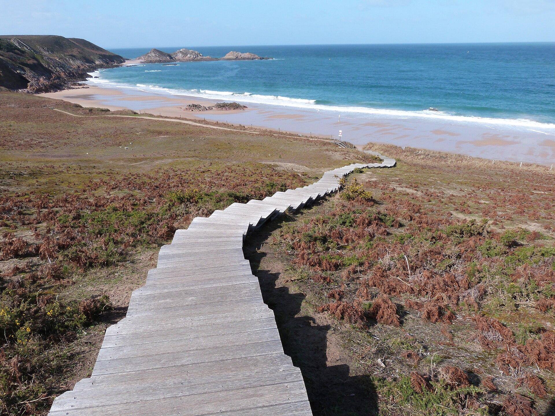
Pink sandstone cliffs, gorse and heather heathland, the Lacs Bleus and four wild beaches: 170 protected hectares on the bay of Saint-Brieuc, crossed by the GR34.
- Suggested time
- 1 hour to half a day
- Type of place
- Headland, pink sandstone cliffs, heathland and wild beaches
- Atmosphere
- Wild and luminous, pink, yellow and purple depending on the season, with wind and sea everywhere
- Getting there
- On foot or by bike: the heart of the Cap is not made for cars. For the big loop of the wild beaches, start from the Cap car park; for the Lacs Bleus and the quarrymen’s path, start from the old port of Erquy, where steps climb along the cliff. The GR34 crosses the whole site, and a cycle path cuts across the heath. An accessible route of about 4.5 km and adapted parking spaces are signposted; the Erquy tourist office provides the map. Motorhomes: overnight stays are banned on the Cap; use the Le Guen area about 700 metres from Le Guen beach. Free access.
Who this place suits
- With family
- 9/10
- As a couple
- 10/10
- With friends
- 9/10
- Solo
- 9/10
- With a dog
- 7/10
- Reduced mobility
- 6/10
These scores are calculated from what the page records: official rating, facilities, difficulty, duration and location. They are a guide, not a substitute for contacting the venue, especially about accessibility.
About
Cap d’Erquy closes the bay of Saint-Brieuc to the east. Over about three kilometres of coast and 170 protected hectares, the landscape keeps changing: pink sandstone cliffs, rocky points, heathland, pine woods, dunes, wetlands, small coves and old quarries. The headland barely rises above sixty metres, but that is enough to overlook the Channel and see, on a clear day, as far as Cap Fréhel. The rock gives the place its identity. It is sandstone, not granite: ancient deposits of sand and pebbles laid down in a delta about 470 million years ago, compacted into a very hard stone that iron oxides tint from pink to red. Folds are still visible in the cliffs, especially towards the Châtelets islet. In spring, yellow gorse adds its colour; from June, purple heather. This sandstone made Erquy’s living. Worked since the Middle Ages, it was mainly quarried from the late 18th century until 1974, for paving stones sent as far as the big cities. Wagons ran on a kilometre of narrow tracks, and a funicular took them down to the harbour. The quarrymen, nicknamed the “sabots râpés” (worn clogs), left pits that filled with water: these are the Lacs Bleus, which are not natural at all and yet are the most photographed spot on the Cap. The Cap has also kept its defences. A bank and a ditch already barred access in the Iron Age. The Trois Pierres guardhouse dates from 1744, and the shot furnace, where cannonballs were heated red-hot to fire at enemy ships, from 1794. At Port-Blanc, the lifeboat shelter was used from 1935 to 1966. Three rocks offshore, a fortified headland, quarries: Albert Uderzo, who knew Erquy well, is said to have drawn on it for Asterix’s village, although the town has never been named as its official location. It is also one of the best-protected natural areas in Brittany: a listed site since 1978, Natura 2000, a departmental sensitive natural area, and under a biotope protection order since July 2023. More than three hundred plant species have been recorded, 55 of them of heritage interest. You may spot the Dartford warbler in the heath, the nightjar at dusk and, in the wet heathland, the Alcon blue, a small blue butterfly that alone justifies part of the protection. With Cap Fréhel, the site forms the Grand Site de France Cap d’Erquy - Cap Fréhel, awarded the label in 2019 and working in 2026 to renew it.
What you will see
- Pink sandstone cliffs about 470 million years old, coloured by iron oxides: sandstone, not granite.
- The Lacs Bleus, former quarries filled with water above the harbour, the most photographed viewpoint on the Cap.
- Four wild beaches free of buildings: Lourtuais, Le Portuais, Le Guen and Lanruen, between rocky headlands and pine woods.
- The wild beaches loop, about 7.5 km and 2 h 30, linking quarries, heathland, the tip of the Cap and coves on the GR34.
- The quarrymen’s path, 1.7 km, telling the story of Erquy’s paving stones, from wagons to the harbour funicular.
- Rare military heritage: a guardhouse from 1744, a shot furnace from 1794, the Port-Blanc lifeboat shelter.
Show 3 more pointsHide
- Heathland in colour: yellow gorse in spring, pink and purple heather from June.
- Protected biodiversity: more than 300 plant species, the Dartford warbler, the nightjar, the Alcon blue.
- A climbing site at the Lacs Bleus: about twenty routes of 15 to 20 metres, graded 3 to 6, guidebook at the tourist office.
Practical information
- Pets
- On a lead on the Cap, compulsory on the GR34
- Lifeguarded swimming
- No, the four wild beaches are not lifeguarded
Tips on the spot
- For a first visit, allow about three hours, combining the Lacs Bleus, the quarrymen’s path, the heathland, the tip of the Cap, the GR34 and a walk down to Lourtuais or Le Portuais.
- With only an hour, climb to the Lacs Bleus from the old port, then on to a viewpoint over the Cap. With half a day, walk the full wild beaches loop.
- The loop is rated easy, but it is a coastal path: climbs, steps, roots, sandy sections and cliff edges. Wear good shoes, especially after rain.
- The four wild beaches are not lifeguarded: currents, tides and wind matter more than elsewhere, especially with children. Part of Lourtuais is a naturist area.
- Dogs on a lead across the Cap, compulsory on the GR34. They are banned from the wild beaches from 15 May to 15 September: check the town’s order for the year.
Show 5 more tipsHide
- In summer, check before you go: in 2026, the Cap road was closed to vehicles from 1 July to 31 August, and the site was closed for a few days in August because of fire risk.
- Fires, barbecues, bivouacs and camping are banned on the Cap, as is horse riding in the biotope protection zone.
- Drones: the protected zone bans low-altitude flights without authorisation.
- Stay on the paths: the heath looks tough, but trampling destroys it.
- With young children, choose the quarrymen’s path, the Lacs Bleus or the accessible route: the cliffs are not protected everywhere. The tourist office offers a treasure hunt for 9 to 12 year olds.
Frequently asked questions
Is the Cap open all year?
In principle yes, but access can be temporarily restricted, especially when the fire risk is high. The site has been closed for a few days for this reason.
How long does a visit take?
One hour for a first look, about 2 h 30 to 3 h for the wild beaches loop, half a day to see everything at your own pace.
What is the main walk?
The wild beaches loop, about 7.5 km and 2 h 30. It is rated easy, but the terrain is natural, with climbs, descents and sections near the cliffs.
Why are the cliffs pink?
They are sandstone, a rock formed about 470 million years ago from sand and pebbles, coloured pink to red by iron oxides. It is not pink granite.
Which beaches are on the Cap?
Lourtuais, Le Portuais, Le Guen and Lanruen. They are wild beaches, not lifeguarded.
Can I drive to the tip?
Motor access is limited and may be banned in summer: in 2026, the Cap road was closed to vehicles from 1 July to 31 August. Park in the car parks provided and continue on foot.
See also all the nature in Brittany.
Stay in Erquy
Places to stay that are still available, with current prices, compared across the main booking platforms.
Partner link: a booking made from this map may earn us a commission, at no extra cost to you.
Read in the journal
- ChristmasWhat to do in Côtes-d’Armor during the Christmas holidaysDinan in winter, scallops, the birds of the bay and Cap Fréhel in the wind: our ideas for the 2026 Christmas holidays in Côtes-d’Armor.
- Winter holidaysWhat to do in Côtes-d’Armor in FebruaryPink granite in the wind, Cap Fréhel, Dinan, scallops and spring tides in the Bay of Saint-Brieuc: our ideas for the February 2027 holidays.
- SeasonWhat to do in Côtes-d’Armor at All Saints’Pink granite, Cap Fréhel, Bréhat, the scallop season and castles: our ideas for the 2026 All Saints’ holidays in Côtes-d’Armor.
Traveller reviews
Nobody has reviewed this place yet.
Photograph: Thérèse Gaigé · CC BY-SA 4.0 · Wikimedia Commons