
Natural site
Huelgoat Forest
Huelgoat · Finistère
A 1,170-hectare state forest in the heart of Finistère: jumbles of granite boulders, the Rivière d’Argent, the Roche Tremblante, the Grotte du Diable and the Camp d’Artus. Free access from the village.
- Suggested time
- 1 hour to half a day
- Type of place
- State forest, granite boulder chaos and river
- Atmosphere
- Fantastical and mossy, alive with water under the rocks, mysterious in the mist
- Getting there
- Huelgoat, central Finistère: D769 from Morlaix, D764 from Carhaix-Plouguer. For a first visit, park in the centre or near the lake and walk in via the Moulin du Chaos: village, restaurants and forest without getting back in the car. Other car parks serve the Arquellen (Camp d’Artus), the Gouffre and the Roche Cintrée. Free access.
Who this place suits
- With family
- 10/10
- As a couple
- 10/10
- With friends
- 9/10
- Solo
- 9/10
- With a dog
- 8/10
- Reduced mobility
- 4/10
These scores are calculated from what the page records: official rating, facilities, difficulty, duration and location. They are a guide, not a substitute for contacting the venue, especially about accessibility.
About
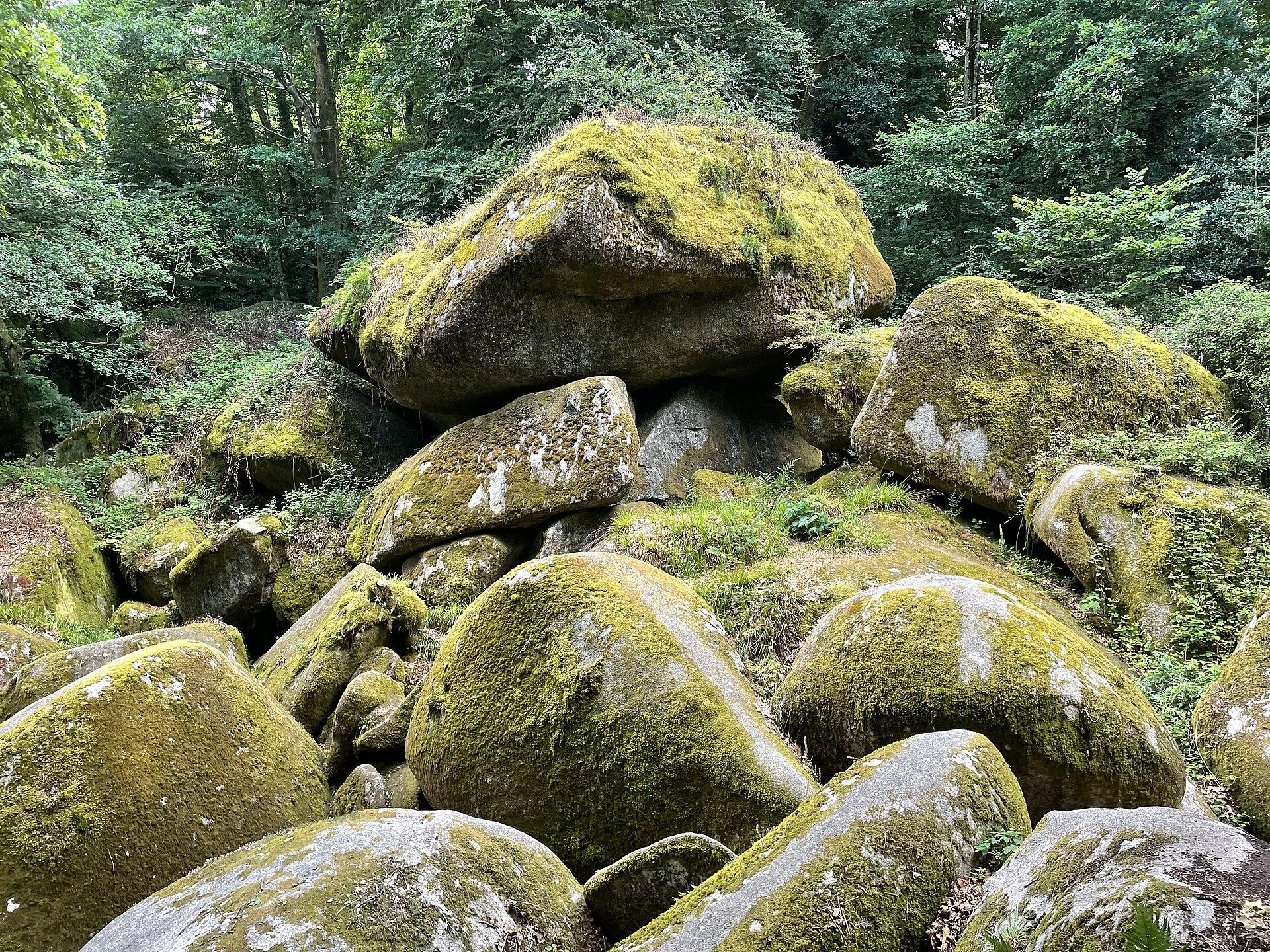
The Huelgoat forest is one of the most astonishing natural sites in Brittany. In the heart of Finistère, at the foot of the Monts d’Arrée and in the Armorique Regional Nature Park, this state forest of about 1,170 hectares is owned by the State and managed by the ONF (the national forestry office). Its name probably comes from the Breton “huel”, high, and “koat”, wood: the high forest. You walk in from the village centre, and within minutes you go from granite houses to a landscape of giant boulders, moss and ferns. The show is all about granite. The massif formed about 315 million years ago, deep inside the ancient Hercynian mountain range, from slowly cooled magma. As erosion wore away the rocks above, it rose towards the surface and cracked; water attacked the cracks, the corners became rounded and the weathered granite around them turned to sand. What remains are boulders weighing from tens to hundreds of tonnes, piled, wedged or tipped over: a chaos. The Rivière d’Argent slips between them, disappears under the stones, then reappears further on. It all begins at the Moulin du Chaos, at the outlet of the lake, whose lintel bears the date 1339. Just after it, the river plunges some twenty metres under the boulders. Then come the Grotte du Diable (Devil’s Grotto), where you climb down between the rocks; the Ménage de la Vierge; the Roche Tremblante (Trembling Rock), about 137 tonnes that a well-placed push is enough to make rock; the Champignon (Mushroom), more than 200 tonnes on a narrow base; then, along the Allée Violette, the Mare aux Fées (Fairies’ Pond) and the Gouffre (Chasm), where the river rushes between the rocks. Every rock has its legend. The best known says that Gargantua, badly fed with buckwheat porridge by the locals, threw these stones at Huelgoat in revenge. It is also said that the fairies combed their hair by their pond, that Dahut, daughter of King Gradlon, threw her lovers into the Gouffre, and that King Arthur slept in the cave that bears his name. The Camp d’Artus, however, is very real and much older: a Gaulish hillfort of the Osismii of about 30 hectares, the largest on the Armorican peninsula, whose ramparts and ditches can still be made out under the trees. The forest also tells an industrial story. The lake, about 15 hectares, was created in the 18th century to supply water to the silver-bearing lead mines of Huelgoat and Locmaria-Berrien, among the most important in the kingdom; they closed for good in 1934, and the Rivière d’Argent (Silver River) probably owes them its name. The mines consumed the forest’s wood, which was later replanted, hence its conifers, now nearly half the trees. The very damp climate feeds mosses, lichens and a rare fern, Wilson’s filmy fern; otters frequent the river, and rare bats hibernate in the old mine galleries.
What you will see
- A jumble of giant granite boulders, from a massif about 315 million years old, a few minutes’ walk from the village.
- The Roche Tremblante, about 137 tonnes, which rocks when you push in the right place: a test of precision, not strength.
- The Rivière d’Argent, which disappears under the rocks then reappears, from the Chaos du Moulin to the Gouffre.
- The Grotte du Diable, where you climb down between the boulders to the sound of the river.
- The Champignon, more than 200 tonnes of granite balanced on a narrow base, and the shapes of the Ménage de la Vierge.
- The Camp d’Artus, a Gaulish hillfort of about 30 hectares, the largest on the Armorican peninsula.
Show 4 more pointsHide
- The Moulin du Chaos, dated 1339 on its lintel, and the lake created for the old lead and silver mines.
- More than 30 km of trails, from the 1.6 km short loop to the 8.9 km discovery loop, with the GR 37 and GR 380.
- A very damp forest covered in moss and ferns, home to otters, the Quimper snail and rare bats.
- Legends at every rock: Gargantua, the Devil, Dahut, the fairies and King Arthur.
Practical information
- Parking
- Huelgoat centre and the lake for the Moulin du Chaos; car parks at the Arquellen (Camp d’Artus), the Gouffre and the Roche Cintrée.
- Pets
- Under control. Lead compulsory from 15 April to 30 June off the forest tracks, advised all year.
- Best time
- Spring for the green and the water, September and October for the colours. Early in the morning to avoid the summer crowds.
Tips on the spot
- The rocks are very slippery, even several days after rain, especially in the Grotte du Diable, by the river and at the Gouffre. Wear hiking boots or trainers with grip, never flip-flops.
- Not all sites have barriers: keep children close, do not climb the boulders and do not leave the path to go down to the bottom of the Gouffre.
- Our route for a first visit (2 h 30 to 3 h): the lake, the Moulin du Chaos, the Grotte du Diable, the Ménage de la Vierge, the Roche Tremblante, the Champignon, the Allée Violette, the Mare aux Fées and the Gouffre. With more time: the Mare aux Sangliers, the Grotte and Camp d’Artus.
- With only an hour: the short scenic loop of about 1.6 km around the Moulin du Chaos, the Grotte du Diable, the Ménage de la Vierge and the Roche Tremblante.
- With young children, take a baby carrier: pushchairs cannot get through the boulders or the Grotte du Diable. The lake loop and the village are easy.
Show 8 more tipsHide
- For the Roche Tremblante, look for the pressure point rather than forcing, and never push while someone is standing on it.
- In autumn and winter, check the ONF hunting calendar for the Huelgoat state forest. If a “chasse en cours” (hunt in progress) sign is up, do not go in.
- This is a working forest: never enter a logging site or climb on log piles, which are very unstable. After a storm, branches may still be hanging: respect closures.
- Dogs welcome, under control. From 15 April to 30 June, leads are compulsory off the forest tracks; they are advised all year because of fawns and wild boar.
- No fires, no barbecues, no cigarette ends, no wild camping. Take all your litter home, peelings included.
- Picking in moderation and for family use only: the ONF generally applies a limit of 5 litres of mushrooms or berries per person. Leave dead wood where it is.
- In summer, more than 2,000 visitors a day on some days according to the ONF: come early in the morning. The best light is in autumn and after light rain.
- Drones: a state forest does not mean free take-off. Check air regulations and ONF conditions before any flight.
Frequently asked questions
How big is it?
About 1,170 hectares of state forest, in the municipalities of Huelgoat, Berrien and Poullaouen. The granite massif beneath covers about 110 km².
Where should I start?
At the lake and the Moulin du Chaos, on the edge of the village. The main sites then follow: the Grotte du Diable, the Ménage de la Vierge, the Roche Tremblante and the Champignon.
How much time should I allow?
An hour for the sites near the Moulin du Chaos, 2 h 30 to 3 h for a good first visit, half a day for the 8.9 km discovery loop, a full day to add the Camp d’Artus.
How did these rocks form?
The granite formed about 315 million years ago, deep underground. As it rose towards the surface it cracked; water weathered the cracks and rounded the corners, then erosion carried away the sand, leaving large piled-up boulders: a chaos. According to legend, Gargantua threw them at Huelgoat, unhappy with a meal of buckwheat porridge.
Can you really make the Roche Tremblante move?
Yes. This block of about 137 tonnes rests on a very small point and rocks slightly when you push in the right place. It is not about strength but precision: even a child can do it if they find the spot.
Is the Grotte du Diable easy to reach?
No. You go down steps and a narrow passage between the boulders, often very slippery. It is not suitable for pushchairs or people with reduced mobility; with very young children, you can just look at it from above.
See also all the nature in Brittany.
Stay in Huelgoat
Places to stay that are still available, with current prices, compared across the main booking platforms.
Partner link: a booking made from this map may earn us a commission, at no extra cost to you.
Read in the journal
- SeasonWhat to do in Finistère during the All Saints’ holidaysThe Pointe du Raz, Océanopolis, the Huelgoat forest, spring tides and the legends of the Monts d’Arrée: our ideas for All Saints’ 2026 in Finistère.
- Winter holidaysWhat to do in Finistère during the February holidaysOcéanopolis, wave battered headlands, spring tides in the Iroise, Locronan and Huelgoat: our ideas for the February 2027 holidays in Finistère.
- ChristmasWhat to do in Finistère during the Christmas holidaysChristmas at Trévarez, the Quimper Christmas village, Locronan lit up, Océanopolis and wild headlands: our ideas for the 2026 Christmas holidays in Finistère.
Traveller reviews
Nobody has reviewed this place yet.
Photograph: Einaz80 · CC BY-SA 4.0 · Wikimedia Commons